Cyclone Arnab: New Weather System Brewing Over Bay of Bengal, Low Pressure Likely on September 19
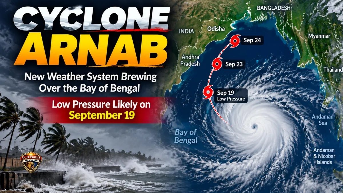
Cyclone Arnab: A new weather system is showing signs of developing over the Bay of Bengal and surrounding seas, putting weather agencies on alert as they closely watch its movement over the coming days. A cyclonic circulation currently positioned over Thailand is gradually moving westward and could reach the northern Andaman Sea by the evening.
According to the information available, the developing system may lead to the formation of a low-pressure area over the northern Andaman Sea by the evening of September 19. Its subsequent movement, organisation and intensity will determine whether it develops into a stronger weather system.
At present, there is no official confirmation that a cyclone will form. However, the possibility of the system strengthening into a depression or deep depression in the days ahead is being closely watched. If it eventually reaches cyclone intensity, the name Arnab could be used.
Cyclone Arnab: Weather System Moving From Thailand Towards Andaman Sea
The current weather development began with a cyclonic circulation over Thailand. Such a circulation represents an area where air is rotating and can sometimes contribute to the development of a low-pressure system when other atmospheric and oceanic conditions are favourable.
The system is expected to gradually move towards the west. Weather observations indicate that it could reach the northern Andaman Sea by the evening.
Its movement over the Andaman Sea will be important because the system could become better organised after entering the surrounding maritime region. Meteorological agencies will continue monitoring its structure and movement to determine how much further it could strengthen.
Low Pressure Area Possible Around September 19
The next major development could occur on September 19, when a low-pressure area may form over the northern Andaman Sea.
A low-pressure area is a relatively weaker weather system, but under favourable atmospheric and oceanic conditions, it can become more organised and intensify. Therefore, the formation of a low-pressure area does not automatically mean that a cyclone is coming.
Once the system forms, forecasters will examine its direction, speed, central pressure and interaction with surrounding atmospheric conditions. These factors will help determine whether the system remains weak or develops into a stronger disturbance.
Next 3 to 4 Days Could Be Important
The three to four days following the formation of the system could prove significant. During this period, the weather disturbance may gradually gain strength and move in a west-northwest direction.
Current indications suggest that the system could travel towards the coastal areas of southern Odisha and northern Andhra Pradesh. However, its exact route cannot be considered fixed at this stage.
Weather systems over the Bay of Bengal can change direction and speed depending on atmospheric conditions. As a result, the projected track may be revised as new observations become available.
System Could Strengthen Into Depression or Deep Depression
The developing low-pressure system could potentially become more organised over the following days. If its intensity increases, it may develop into a depression or deep depression.
Several factors will influence this development. These include the speed at which the system moves, atmospheric circulation around it and the conditions over the sea. Warm ocean waters and favourable atmospheric conditions can support further organisation, while unfavourable conditions can limit development.
For this reason, it is too early to determine the final strength of the system.
September 23 and 24 May See Faster Movement
September 23 and 24 are expected to be particularly important for tracking the system. During this period, the weather disturbance could pick up speed and move more quickly.
Around September 24, the system may move towards northern Odisha, according to the current indications. If it becomes stronger, rainfall could intensify across parts of Odisha and Andhra Pradesh.
Coastal areas will need to be watched carefully as the system approaches. Apart from rainfall, stronger winds could also become a concern if the system gains sufficient strength.
However, the exact locations likely to receive heavy rain and the expected wind speeds will depend on the system’s position and intensity closer to the event.
Heavy Rainfall Possible in Parts of Odisha and Andhra Pradesh
The developing system could bring heavy rainfall to some areas of southern Odisha and northern Andhra Pradesh.
The distribution and intensity of rainfall will depend largely on how organised the low-pressure system becomes. If the disturbance strengthens, the area affected by rain could expand and rainfall intensity could increase.
Coastal areas could also experience stronger winds along with rainfall. At this stage, however, it would be premature to specify exact rainfall totals or wind speeds because the system is still developing.
More reliable details are expected as the weather disturbance moves closer to the Indian coastline and its structure becomes clearer.
Is a Cyclone Expected to Hit India?
One of the biggest questions surrounding the developing system is whether it will eventually become a cyclone.
Based on the information provided, there is currently no official forecast confirming the formation of a cyclone. The system is still being monitored at the low-pressure stage, with the possibility of further development into a depression or deep depression.
Only if the system continues to strengthen and meets the required criteria would it be classified as a cyclone.
Therefore, reports referring to Cyclone Arnab at this stage should be understood as referring to a possible future development rather than a confirmed cyclone.
Why Could the Cyclone Be Named Arnab?
If the weather system eventually intensifies into an officially recognised cyclonic storm over the Bay of Bengal, the name Arnab could be used.
The name has been assigned by Bangladesh under the regional cyclone naming system. However, the use of the name depends entirely on whether the developing system reaches the required intensity to be classified as a cyclone.
At present, therefore, Cyclone Arnab is not a confirmed storm. The name is relevant only to a possible future scenario if the system strengthens sufficiently.
No Storm Warning Has Been Issued Yet
There is currently no storm warning for the sea areas in connection with this developing system.
This means there is no direct cyclone warning at the present stage. The system remains under observation, and further decisions will depend on how it develops over the coming days.
The movement from the Andaman Sea into the Bay of Bengal will be particularly important. Changes in its direction, speed and strength could significantly affect the weather forecast for Odisha, Andhra Pradesh and nearby coastal regions.
September 19 to 24 Will Be Crucial
The period from September 19 to September 24 is likely to be important for understanding the future of the system.
The first key stage could come on September 19, when a low-pressure area may form over the northern Andaman Sea. After that, the system could gradually become stronger over the next three to four days.
By September 23 and 24, its movement could accelerate, with current indications pointing towards northern Odisha.
The exact track, however, may change as the system develops. Weather forecasts for a developing system are regularly updated because even relatively small changes in atmospheric conditions can influence its movement and intensity.
More Updates Expected as the System Develops
For now, there is no basis for treating the formation of Cyclone Arnab as a certainty. The key issue is whether the developing weather system will organise enough to move through the different stages of intensification.
The immediate focus remains on the possible formation of a low-pressure area on September 19, followed by its movement and potential strengthening over the next several days.
Further weather updates are expected to provide greater clarity about the system’s intensity, path and possible impact on coastal areas. Until then, people in potentially affected regions should rely on official weather updates rather than unverified cyclone claims circulating online.
The coming days will reveal whether the system remains a low-pressure disturbance, develops into a depression or deep depression, or eventually reaches cyclone intensity and takes the name Arnab.
Also read: Ganeshotsav 2026: Adani Group Joins 107-Year-Old Chinchpokli Chintamani Mandal in Mumbai